Thank you for supporting this site ❤️
Make a donation
Make a donation
Gear up for your next adventure:
As an Amazon Associate, this site earns from qualifying purchases at no extra cost to you.
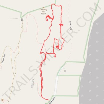
Orenaug Park
- Distance: 1.7 Km
- Elevation gain: 43 m
- Maximum elevation: 154 m
- Elevation loss: 54 m
- Minimum elevation: 121 m
- Moving time: 29 m 26 s
- Moving speed: 3.5 Km/h
- Maximum speed: 8.6 Km/h
- Total time: 1 h 23 m
- Global speed: 1.2 Km/h
Interactive trail map
Thank you for supporting this site ❤️
Make a donation
Make a donation
Gear up for your next adventure:
As an Amazon Associate, this site earns from qualifying purchases at no extra cost to you.
Trail profile
- Distance: 1.7 Km
- Elevation gain: 43 m
- Maximum elevation: 154 m
- Elevation loss: 54 m
- Minimum elevation: 121 m
- Moving time: 29 m 26 s
- Moving speed: 3.5 Km/h
- Maximum speed: 8.6 Km/h
- Total time: 1 h 23 m
- Global speed: 1.2 Km/h
Thank you for supporting this site ❤️
Make a donation
Make a donation
Gear up for your next adventure:
As an Amazon Associate, this site earns from qualifying purchases at no extra cost to you.
About this trail
Name: Orenaug Park trail, distance, elevation, map, profile, GPS track
Coordinates: 41.53973 -73.20201 41.54415 -73.20050
Thank you for supporting this site ❤️
Make a donation
Make a donation
Gear up for your next adventure:
As an Amazon Associate, this site earns from qualifying purchases at no extra cost to you.