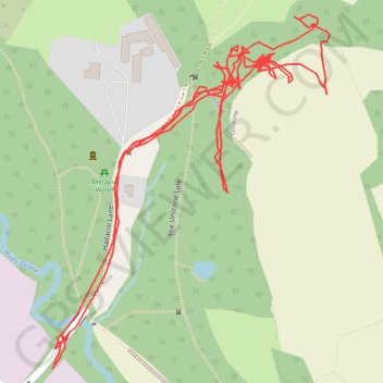
RE SK370780 2
- Distance: 2.5 Km
- Elevation gain: 40 m
- Maximum elevation: 132 m
- Elevation loss: 40 m
- Minimum elevation: 102 m
- Moving time: 1 h 3 m
- Moving speed: 2.4 Km/h
- Maximum speed: 6.1 Km/h
- Total time: 23 h 9 m
- Global speed: 0.1 Km/h
Interactive trail map
Trail profile
- Distance: 2.5 Km
- Elevation gain: 40 m
- Maximum elevation: 132 m
- Elevation loss: 40 m
- Minimum elevation: 102 m
- Moving time: 1 h 3 m
- Moving speed: 2.4 Km/h
- Maximum speed: 6.1 Km/h
- Total time: 23 h 9 m
- Global speed: 0.1 Km/h
About this trail
Name: RE SK370780 2 trail, distance, elevation, map, profile, GPS track
Coordinates: 53.29496 -1.44929 53.29849 -1.44467