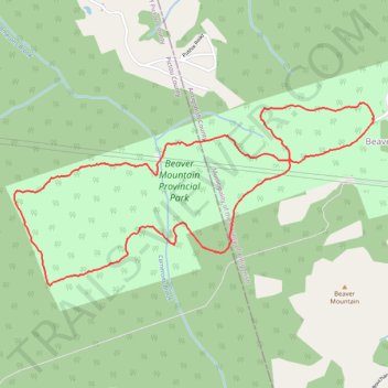
Beaver Mountain Provincial Park Loop Trail
- Distance: 5.8 Km
- Elevation gain: 127 m
- Maximum elevation: 238 m
- Elevation loss: 127 m
- Minimum elevation: 167 m
- Moving time: 1 h 34 m
- Moving speed: 3.7 Km/h
- Maximum speed: 8.5 Km/h
- Total time: 1 h 36 m
- Global speed: 3.6 Km/h
Interactive trail map
Trail profile
- Distance: 5.8 Km
- Elevation gain: 127 m
- Maximum elevation: 238 m
- Elevation loss: 127 m
- Minimum elevation: 167 m
- Moving time: 1 h 34 m
- Moving speed: 3.7 Km/h
- Maximum speed: 8.5 Km/h
- Total time: 1 h 36 m
- Global speed: 3.6 Km/h
About this trail
Name: Beaver Mountain Provincial Park Loop Trail trail, distance, elevation, map, profile, GPS track
Coordinates: 45.55800 -62.18045 45.56661 -62.15634
Topography: Municipality of the County of Antigonish topographic map, elevation, terrain
Other hiking, mountain biking, running and outdoor activity trails
Click on a trail to view its statistics, map and profile.
Pictou - Antigonish
Canada > Nova Scotia > Town of Pictou > Pictou
#Bike #Pictou #Antigonish
Distance: 74.3 Km • Elevation gain: 744 m • Maximum elevation: 154 m