Thank you for supporting this site ❤️
Make a donation
Make a donation
Gear up for your next adventure:
As an Amazon Associate, this site earns from qualifying purchases at no extra cost to you.
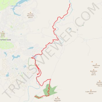
2026/04/11 CT - 10.1 Daddy's Creek
- Distance: 24.3 Km
- Elevation gain: 569 m
- Maximum elevation: 590 m
- Elevation loss: 678 m
- Minimum elevation: 412 m
- Moving time: 5 h 31 m
- Moving speed: 4.4 Km/h
- Maximum speed: 8.7 Km/h
- Total time: 6 h 10 m
- Global speed: 3.9 Km/h
Interactive trail map
Thank you for supporting this site ❤️
Make a donation
Make a donation
Gear up for your next adventure:
As an Amazon Associate, this site earns from qualifying purchases at no extra cost to you.
Trail profile
- Distance: 24.3 Km
- Elevation gain: 569 m
- Maximum elevation: 590 m
- Elevation loss: 678 m
- Minimum elevation: 412 m
- Moving time: 5 h 31 m
- Moving speed: 4.4 Km/h
- Maximum speed: 8.7 Km/h
- Total time: 6 h 10 m
- Global speed: 3.9 Km/h
Thank you for supporting this site ❤️
Make a donation
Make a donation
Gear up for your next adventure:
As an Amazon Associate, this site earns from qualifying purchases at no extra cost to you.
About this trail
Name: 2026/04/11 CT - 10.1 Daddy's Creek trail, distance, elevation, map, profile, GPS track
Coordinates: 35.94679 -84.85619 36.03432 -84.81128
Thank you for supporting this site ❤️
Make a donation
Make a donation
Gear up for your next adventure:
As an Amazon Associate, this site earns from qualifying purchases at no extra cost to you.