Make a donation
Gear up for your next adventure:
As an Amazon Associate, this site earns from qualifying purchases at no extra cost to you.
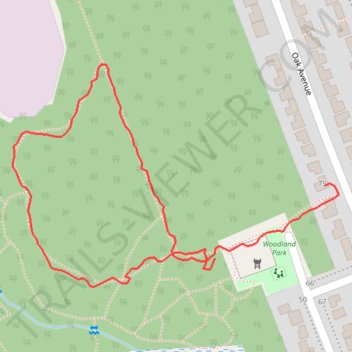
Woodland Park
- Distance: 1.1 Km
- Elevation gain: 13 m
- Maximum elevation: 156 m
- Elevation loss: 13 m
- Minimum elevation: 143 m
- Moving time: 22 m 2 s
- Moving speed: 2.9 Km/h
- Maximum speed: 22.3 Km/h
- Total time: 23 m 57 s
- Global speed: 2.7 Km/h
Interactive trail map
Make a donation
Gear up for your next adventure:
As an Amazon Associate, this site earns from qualifying purchases at no extra cost to you.
Trail profile
- Distance: 1.1 Km
- Elevation gain: 13 m
- Maximum elevation: 156 m
- Elevation loss: 13 m
- Minimum elevation: 143 m
- Moving time: 22 m 2 s
- Moving speed: 2.9 Km/h
- Maximum speed: 22.3 Km/h
- Total time: 23 m 57 s
- Global speed: 2.7 Km/h
Make a donation
Gear up for your next adventure:
As an Amazon Associate, this site earns from qualifying purchases at no extra cost to you.
About this trail
Name: Woodland Park trail, distance, elevation, map, profile, GPS track
Coordinates: 45.88937 -77.28842 45.89165 -77.28363
Topography: Renfrew County topographic map, elevation, terrain
Make a donation
Gear up for your next adventure:
As an Amazon Associate, this site earns from qualifying purchases at no extra cost to you.
Other hiking, mountain biking, running and outdoor activity trails
Click on a trail to view its statistics, map and profile.
Petawawa woodland trails
Canada > Ontario > Renfrew County > Petawawa
Distance: 3.8 Km • Elevation gain: 26 m • Maximum elevation: 156 m
Woodland Park
Canada > Ontario > Renfrew County > Petawawa
Distance: 1.1 Km • Elevation gain: 10 m • Maximum elevation: 157 m