Make a donation
Gear up for your next adventure:
As an Amazon Associate, this site earns from qualifying purchases at no extra cost to you.
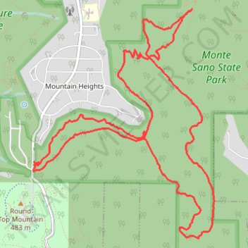
Arrowhead Trail and Natural Well Trail Loop in Monte Sano State Park
Arrowhead
- Distance: 12.3 Km
- Elevation gain: 371 m
- Maximum elevation: 462 m
- Elevation loss: 371 m
- Minimum elevation: 276 m
Interactive trail map
Make a donation
Gear up for your next adventure:
As an Amazon Associate, this site earns from qualifying purchases at no extra cost to you.
Trail profile
- Distance: 12.3 Km
- Elevation gain: 371 m
- Maximum elevation: 462 m
- Elevation loss: 371 m
- Minimum elevation: 276 m
Make a donation
Gear up for your next adventure:
As an Amazon Associate, this site earns from qualifying purchases at no extra cost to you.
About this trail
Name: Arrowhead Trail and Natural Well Trail Loop in Monte Sano State Park trail, distance, elevation, map, profile, GPS track
Coordinates: 34.71368 -86.53752 34.73703 -86.51511
Make a donation
Gear up for your next adventure:
As an Amazon Associate, this site earns from qualifying purchases at no extra cost to you.
Other hiking, mountain biking, running and outdoor activity trails
Click on a trail to view its statistics, map and profile.
25 mile Bike Ride, Huntsville/Gurley AL
United States > Alabama > Madison County > Huntsville > Five Points
Moontown Airport
Distance: 40.5 Km • Elevation gain: 377 m • Maximum elevation: 307 m
McKay Trail/Monte Sano State Park (MSSP) ride
United States > Alabama > Madison County > Huntsville
Distance: 14.4 Km • Elevation gain: 323 m • Maximum elevation: 502 m
Monte Sano Loop Ride
United States > Alabama > Madison County > Huntsville
Afternoon Mountain Bike Ride
Distance: 13.0 Km • Elevation gain: 284 m • Maximum elevation: 492 m