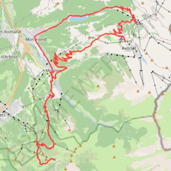
Col de Youx Plane en montée d'Avoriaz
Col de Youx Plane en montée d'Avoriaz. Mooie cols en rustige banen. De Youx Plane is de zwaarste, vooral door zijn onregelmatigheid. Maar je hebt er ook fantastische zichten op de Mont Blanc. De klim naar Avoriaz is totaal verschillend, een loper. Niet onregelmatig, wel mooi. Hier heb je dan in de haarspeldbochten prachtige zichten op Morzine. Uitrusten kan je aan het mooie meer van Montriond.
- Distance: 52.4 Km
- Elevation gain: 1,964 m
- Maximum elevation: 1,815 m
- Elevation loss: 1,966 m
- Minimum elevation: 941 m
Interactive trail map
Trail profile
- Distance: 52.4 Km
- Elevation gain: 1,964 m
- Maximum elevation: 1,815 m
- Elevation loss: 1,966 m
- Minimum elevation: 941 m
About this trail
Name: Col de Youx Plane en montée d'Avoriaz trail, distance, elevation, map, profile, GPS track
Coordinates: 46.12704 6.69364 46.21582 6.77640
Other hiking, mountain biking, running and outdoor activity trails
Click on a trail to view its statistics, map and profile.
PT23DS2 Lörrach → Cadaqués
Germany > Baden-Württemberg > Landkreis Lörrach > Lörrach (Kernstadt)
Distance: 1,050.7 Km • Elevation gain: 13,130 m • Maximum elevation: 1,505 m