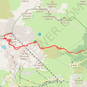
Le Pic du Midi-de-Bigorre par le sentier des muletiers
- Distance: 18.8 Km
- Elevation gain: 1,714 m
- Maximum elevation: 2,855 m
- Elevation loss: 1,714 m
- Minimum elevation: 1,281 m
Interactive trail map
Trail profile
- Distance: 18.8 Km
- Elevation gain: 1,714 m
- Maximum elevation: 2,855 m
- Elevation loss: 1,714 m
- Minimum elevation: 1,281 m
About this trail
Name: Le Pic du Midi-de-Bigorre par le sentier des muletiers trail, distance, elevation, map, profile, GPS track
Coordinates: 42.92534 0.13438 42.93716 0.19843
Other hiking, mountain biking, running and outdoor activity trails
Click on a trail to view its statistics, map and profile.
Southern section — European Divide Trail
France > Auvergne-Rhône-Alpes > Drôme > Valence
Distance: 2,423.8 Km • Elevation gain: 42,375 m • Maximum elevation: 2,005 m
GR 10 - Traversée des Pyrénées
France > Occitania > Pyrénées-Orientales > Banyuls-sur-Mer
Distance: 874.8 Km • Elevation gain: 57,000 m • Maximum elevation: 2,599 m
1 LUCENA - MONTPELLIER
Distance: 2,964.4 Km • Elevation gain: 29,500 m • Maximum elevation: 1,048 m