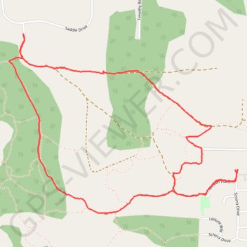
Import a GPX file

Nanoose Bay Loop

Vancouver Island. #Hiking #Running #Loop #Vancouver

  • Distance: 5.4 Km
  • Elevation gain: 93 m
  • Maximum elevation: 115 m
  • Elevation loss: 93 m
  • Minimum elevation: 63 m

Interactive trail map

Trail profile

  • Distance: 5.4 Km
  • Elevation gain: 93 m
  • Maximum elevation: 115 m
  • Elevation loss: 93 m
  • Minimum elevation: 63 m

About this trail

Other hiking, mountain biking, running and outdoor activity trails

Click on a trail to view its statistics, map and profile.

Nanaimo - Fanny Bay

Canada > British Columbia > Regional District of Nanaimo > Nanaimo

Vancouver Island. #Bike #Nanaimo #Fanny #Vancouver

Distance: 72.4 Km • Elevation gain: 664 m • Maximum elevation: 123 m

Sproat Lake - Nanaimo

Canada > British Columbia > Alberni-Clayoquot Regional District > Area D (Sproat Lake)

#Bike #SproatLake #Nanaimo

Distance: 87.0 Km • Elevation gain: 1,273 m • Maximum elevation: 422 m

Gear up for your next adventure:

🧥Ultralight Puffy Jacket - Maximum warmth that packs down to the size of an orange
🎒Backpack Rain Cover - External shield to keep your entire pack dry
Tent Footprint - Protect tent floor and increase durability
🧴Waterproofing Spray - Restore the DWR coating on jackets and tents
🪑Insulated Seat Pad - Protect your seat from cold rocks and wet logs

As an Amazon Associate, this site earns from qualifying purchases at no extra cost to you.