Thank you for supporting this site ❤️
Make a donation
Make a donation
Gear up for your next adventure:
As an Amazon Associate, this site earns from qualifying purchases at no extra cost to you.
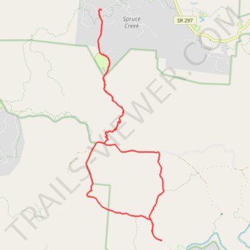
Big South Fork National River and Recreation Area
- Distance: 21.4 Km
- Elevation gain: 305 m
- Maximum elevation: 501 m
- Elevation loss: 305 m
- Minimum elevation: 420 m
Interactive trail map
Thank you for supporting this site ❤️
Make a donation
Make a donation
Gear up for your next adventure:
As an Amazon Associate, this site earns from qualifying purchases at no extra cost to you.
Trail profile
- Distance: 21.4 Km
- Elevation gain: 305 m
- Maximum elevation: 501 m
- Elevation loss: 305 m
- Minimum elevation: 420 m
Thank you for supporting this site ❤️
Make a donation
Make a donation
Gear up for your next adventure:
As an Amazon Associate, this site earns from qualifying purchases at no extra cost to you.
About this trail
Name: Big South Fork National River and Recreation Area trail, distance, elevation, map, profile, GPS track
Coordinates: 36.41726 -84.80512 36.48189 -84.77809
Thank you for supporting this site ❤️
Make a donation
Make a donation
Gear up for your next adventure:
As an Amazon Associate, this site earns from qualifying purchases at no extra cost to you.