Import a GPX file

Disc Golf course at Ward Farm Park

  • Distance: 2.6 Km
  • Elevation gain: 40 m
  • Maximum elevation: 37 m
  • Elevation loss: 42 m
  • Minimum elevation: 8 m

Interactive trail map

Trail profile

  • Distance: 2.6 Km
  • Elevation gain: 40 m
  • Maximum elevation: 37 m
  • Elevation loss: 42 m
  • Minimum elevation: 8 m

About this trail
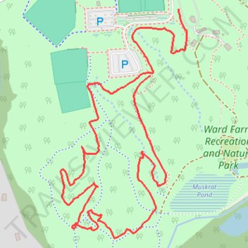
Name: Disc Golf course at Ward Farm Park trail, distance, elevation, map, profile, GPS track

Start: Ward Road, Woodlawn Farms, Dunkirk, Calvert County, Maryland, 20754, United States (38.72130 -76.64497)

End: Ward Road, Woodlawn Farms, Dunkirk, Calvert County, Maryland, 20754, United States (38.71963 -76.64587)

Coordinates: 38.71557 -76.64874 38.72130 -76.64471

Other hiking, mountain biking, running and outdoor activity trails

Click on a trail to view its statistics, map and profile.
Ward Farm Recreation and Nature Park loop

United States > Maryland > Calvert County > Dunkirk > Woodlawn Farms

Distance: 3.8 Km • Elevation gain: 51 m • Maximum elevation: 37 m

Gear up for your next adventure:

🧢Outdoor Cap - Protective cap for sun and rain during hikes
🏃Hydration Running Vest - Carry water and maps close to your body for speed
🥾Hiking Boots - Sturdy boots providing ankle support and traction on rugged trails
🧤Thermal Hiking Gloves - Grip-enhanced gloves for cold-weather altitude trekking
👟Sport Hiking Sandals - Breathable footwear for water crossings and camp rest

As an Amazon Associate, this site earns from qualifying purchases at no extra cost to you.