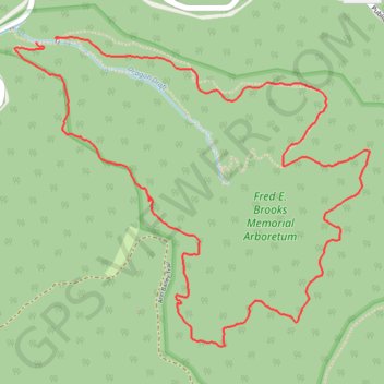
Honeybee Trail - Watoga State Park
- Distance: 7.0 Km
- Elevation gain: 272 m
- Maximum elevation: 912 m
- Elevation loss: 274 m
- Minimum elevation: 742 m
- Moving time: 13 m 5 s
- Moving speed: 32.0 Km/h
- Maximum speed: 44.9 Km/h
- Total time: 13 m 5 s
- Global speed: 32.0 Km/h
Interactive trail map
Trail profile
- Distance: 7.0 Km
- Elevation gain: 272 m
- Maximum elevation: 912 m
- Elevation loss: 274 m
- Minimum elevation: 742 m
- Moving time: 13 m 5 s
- Moving speed: 32.0 Km/h
- Maximum speed: 44.9 Km/h
- Total time: 13 m 5 s
- Global speed: 32.0 Km/h
About this trail
Name: Honeybee Trail - Watoga State Park trail, distance, elevation, map, profile, GPS track
Start: Honey Bee Trail, Pocahontas County, West Virginia, United States (38.11938 -80.15425)
End: Honey Bee Trail, Pocahontas County, West Virginia, United States (38.11922 -80.15549)
Coordinates: 38.10542 -80.15675 38.11945 -80.13631