Make a donation
Gear up for your next adventure:
As an Amazon Associate, this site earns from qualifying purchases at no extra cost to you.
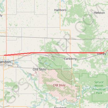
Brandon - Sidney
Interactive trail map
Make a donation
Gear up for your next adventure:
As an Amazon Associate, this site earns from qualifying purchases at no extra cost to you.
Trail profile
- Distance: 66.4 Km
- Elevation gain: 104 m
- Maximum elevation: 407 m
- Elevation loss: 133 m
- Minimum elevation: 376 m
Make a donation
Gear up for your next adventure:
As an Amazon Associate, this site earns from qualifying purchases at no extra cost to you.
About this trail
Name: Brandon - Sidney trail, distance, elevation, map, profile, GPS track
End: Sidney, Municipality of North Norfolk, Manitoba, Canada (49.90255 -99.05858)
Coordinates: 49.88680 -99.95570 49.90255 -99.05858
Topography: Brandon topographic map, elevation, terrain
Make a donation
Gear up for your next adventure:
As an Amazon Associate, this site earns from qualifying purchases at no extra cost to you.
Other hiking, mountain biking, running and outdoor activity trails
Click on a trail to view its statistics, map and profile.
Sidney - Portage la Prairie
Canada > Municipality of North Norfolk > Sidney
#Bike #Sidney #PortageLaPrairie
Distance: 59.1 Km • Elevation gain: 39 m • Maximum elevation: 379 m