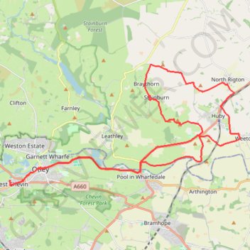
Otley - Pool - Castley - Stainburn - Braythorne - Almscliffe Crag - Weeton - Otley
Interactive trail map
Trail profile
- Distance: 34.6 Km
- Elevation gain: 356 m
- Maximum elevation: 204 m
- Elevation loss: 356 m
- Minimum elevation: 42 m
- Moving time: 2 h 49 m
- Moving speed: 12.2 Km/h
- Maximum speed: 31.4 Km/h
- Total time: 5 h 50 m
- Global speed: 5.9 Km/h
About this trail
Name: Otley - Pool - Castley - Stainburn - Braythorne - Almscliffe Crag - Weeton - Otley trail, distance, elevation, map, profile, GPS track
Coordinates: 53.89940 -1.71330 53.94427 -1.56747
Other hiking, mountain biking, running and outdoor activity trails
Click on a trail to view its statistics, map and profile.
Otley - Farnley - Clifton - Otley (foot)
United Kingdom > England > North Yorkshire > Otley
Distance: 7.6 Km • Elevation gain: 144 m • Maximum elevation: 209 m
Otley - Draughton/Skipton Moor and return
United Kingdom > England > Leeds
Distance: 41.3 Km • Elevation gain: 456 m • Maximum elevation: 318 m
Otley - Eccup Reservoir - Harewood Bank - Otley (bicycle)
United Kingdom > England > Otley
Distance: 34.9 Km • Elevation gain: 377 m • Maximum elevation: 179 m
Otley - Eccup Reservoir - Harewood Bank - Otley (bicycle)
United Kingdom > England > Otley
Distance: 34.5 Km • Elevation gain: 364 m • Maximum elevation: 178 m
Otley Chevin
United Kingdom > England > Otley
Distance: 8.8 Km • Elevation gain: 238 m • Maximum elevation: 278 m