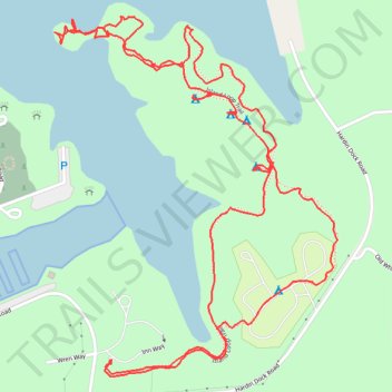
Hike - Pickwick Landing Island Loop Trail
- Distance: 5.7 Km
- Elevation gain: 57 m
- Maximum elevation: 147 m
- Elevation loss: 57 m
- Minimum elevation: 128 m
- Moving time: 1 h 12 m
- Moving speed: 4.7 Km/h
- Maximum speed: 21.3 Km/h
- Total time: 1 h 27 m
- Global speed: 3.9 Km/h
Interactive trail map
Trail profile
- Distance: 5.7 Km
- Elevation gain: 57 m
- Maximum elevation: 147 m
- Elevation loss: 57 m
- Minimum elevation: 128 m
- Moving time: 1 h 12 m
- Moving speed: 4.7 Km/h
- Maximum speed: 21.3 Km/h
- Total time: 1 h 27 m
- Global speed: 3.9 Km/h
About this trail
Name: Hike - Pickwick Landing Island Loop Trail trail, distance, elevation, map, profile, GPS track
Coordinates: 35.05071 -88.23279 35.06029 -88.22366
Other hiking, mountain biking, running and outdoor activity trails
Click on a trail to view its statistics, map and profile.
Gmaps Pedometer Route
United States > Kentucky > Fulton County > Hickman
Distance: 502.9 Km • Elevation gain: 4,204 m • Maximum elevation: 592 m