Import a GPX file

Dishman Hills Conservation Area loop hike

  • Distance: 6.0 Km
  • Elevation gain: 188 m
  • Maximum elevation: 733 m
  • Elevation loss: 188 m
  • Minimum elevation: 613 m
  • Moving time: 1 h 23 m
  • Moving speed: 4.3 Km/h
  • Maximum speed: 6.8 Km/h
  • Total time: 1 h 27 m
  • Global speed: 4.1 Km/h

Interactive trail map

Trail profile

  • Distance: 6.0 Km
  • Elevation gain: 188 m
  • Maximum elevation: 733 m
  • Elevation loss: 188 m
  • Minimum elevation: 613 m
  • Moving time: 1 h 23 m
  • Moving speed: 4.3 Km/h
  • Maximum speed: 6.8 Km/h
  • Total time: 1 h 27 m
  • Global speed: 4.1 Km/h

About this trail
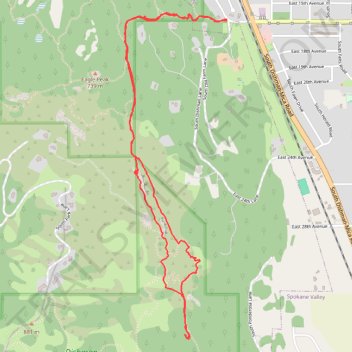
Name: Dishman Hills Conservation Area loop hike trail, distance, elevation, map, profile, GPS track

Start: 1598, South Bluff Drive, Mica Park, Spokane Valley, Spokane County, Washington, 99206, United States (47.64246 -117.27565)

End: 1598, South Bluff Drive, Mica Park, Spokane Valley, Spokane County, Washington, 99206, United States (47.64254 -117.27565)

Coordinates: 47.62553 -117.28374 47.64286 -117.27565

Gear up for your next adventure:

🧢Sun Hat - Wide-brim hat for sun protection
🧊Portable Cooler - Keep food and drinks cold during outdoor adventures
🦌Outdoor Trail Camera - Monitor wildlife activity near your favorite spots
🚲Handlebar Phone Mount - View topographic-map.com live while cycling
🔭Compact Monocular - One-handed bird watching and trail spotting

As an Amazon Associate, this site earns from qualifying purchases at no extra cost to you.