Make a donation
Gear up for your next adventure:
As an Amazon Associate, this site earns from qualifying purchases at no extra cost to you.
Latourell Falls Loop
Interactive trail map
Make a donation
Gear up for your next adventure:
As an Amazon Associate, this site earns from qualifying purchases at no extra cost to you.
Trail profile
- Distance: 3.3 Km
- Elevation gain: 267 m
- Maximum elevation: 227 m
- Elevation loss: 267 m
- Minimum elevation: 40 m
Make a donation
Gear up for your next adventure:
As an Amazon Associate, this site earns from qualifying purchases at no extra cost to you.
About this trail
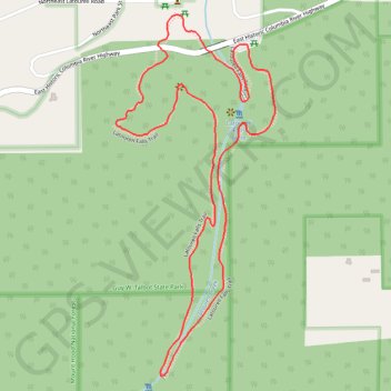
Name: Latourell Falls Loop trail, distance, elevation, map, profile, GPS track
Coordinates: 45.53070 -122.22227 45.53947 -122.21674
Make a donation
Gear up for your next adventure:
As an Amazon Associate, this site earns from qualifying purchases at no extra cost to you.
Other hiking, mountain biking, running and outdoor activity trails
Click on a trail to view its statistics, map and profile.
Latourell Falls Loop Trail in Guy W. Talbot State Park
United States > Oregon > Multnomah County > Latourell
The Latourell Falls Loop Trail offers a picturesque and relatively moderate hike through the lush forests of the Columbia River Gorge. Starting near the impressive Lower Latourell Falls, the trail quickly immerses you in a verdant landscape filled with moss-covered trees and ferns. As you ascend, you'll…
Distance: 3.6 Km • Elevation gain: 284 m • Maximum elevation: 240 m
Expedition to Sedum Ridge
United States > Oregon > Multnomah County > Portland
Distance: 214.7 Km • Elevation gain: 5,093 m • Maximum elevation: 1,169 m