Thank you for supporting this site ❤️
Make a donation
Make a donation
Gear up for your next adventure:
As an Amazon Associate, this site earns from qualifying purchases at no extra cost to you.
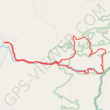
Devils Path via Devils Bridge
- Distance: 11.1 Km
- Elevation gain: 719 m
- Maximum elevation: 1,360 m
- Elevation loss: 719 m
- Minimum elevation: 939 m
- Moving time: 3 h 13 m
- Moving speed: 3.4 Km/h
- Maximum speed: 15.7 Km/h
- Total time: 4 h 22 m
- Global speed: 2.5 Km/h
Interactive trail map
Thank you for supporting this site ❤️
Make a donation
Make a donation
Gear up for your next adventure:
As an Amazon Associate, this site earns from qualifying purchases at no extra cost to you.
Trail profile
- Distance: 11.1 Km
- Elevation gain: 719 m
- Maximum elevation: 1,360 m
- Elevation loss: 719 m
- Minimum elevation: 939 m
- Moving time: 3 h 13 m
- Moving speed: 3.4 Km/h
- Maximum speed: 15.7 Km/h
- Total time: 4 h 22 m
- Global speed: 2.5 Km/h
Thank you for supporting this site ❤️
Make a donation
Make a donation
Gear up for your next adventure:
As an Amazon Associate, this site earns from qualifying purchases at no extra cost to you.
About this trail
Name: Devils Path via Devils Bridge trail, distance, elevation, map, profile, GPS track
Start: Дяволска екопътека, Borino, Smolyan, 4836, Bulgaria (41.65620 24.30298)
End: Дяволска екопътека, Borino, Smolyan, 4836, Bulgaria (41.65642 24.30274)
Coordinates: 41.64874 24.30274 41.65788 24.33530
Thank you for supporting this site ❤️
Make a donation
Make a donation
Gear up for your next adventure:
As an Amazon Associate, this site earns from qualifying purchases at no extra cost to you.