Thank you for supporting this site ❤️
Make a donation
Make a donation
Gear up for your next adventure:
As an Amazon Associate, this site earns from qualifying purchases at no extra cost to you.
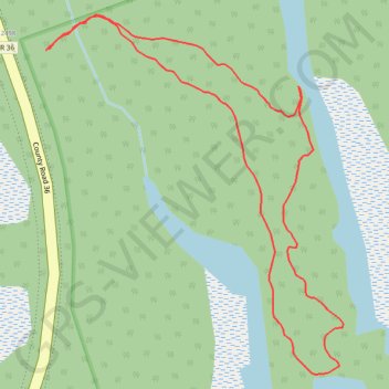
Mississauga River Loop
Kawartha Highlands Signature Site. #Hiking #Snowshoeing #Loop #Kawartha
- Distance: 1.6 Km
- Elevation gain: 8 m
- Maximum elevation: 251 m
- Elevation loss: 8 m
- Minimum elevation: 245 m
Interactive trail map
Thank you for supporting this site ❤️
Make a donation
Make a donation
Gear up for your next adventure:
As an Amazon Associate, this site earns from qualifying purchases at no extra cost to you.
Trail profile
- Distance: 1.6 Km
- Elevation gain: 8 m
- Maximum elevation: 251 m
- Elevation loss: 8 m
- Minimum elevation: 245 m
Thank you for supporting this site ❤️
Make a donation
Make a donation
Gear up for your next adventure:
As an Amazon Associate, this site earns from qualifying purchases at no extra cost to you.
About this trail
Name: Mississauga River Loop trail, distance, elevation, map, profile, GPS track
Coordinates: 44.57296 -78.35911 44.57719 -78.35420
Topography: Trent Lakes topographic map, elevation, terrain
Thank you for supporting this site ❤️
Make a donation
Make a donation
Gear up for your next adventure:
As an Amazon Associate, this site earns from qualifying purchases at no extra cost to you.
Other hiking, mountain biking, running and outdoor activity trails
Click on a trail to view its statistics, map and profile.