Thank you for supporting this site ❤️
Make a donation
Make a donation
Gear up for your next adventure:
As an Amazon Associate, this site earns from qualifying purchases at no extra cost to you.
Birds Hill Park - Prairie Winds Trail
Interactive trail map
Thank you for supporting this site ❤️
Make a donation
Make a donation
Gear up for your next adventure:
As an Amazon Associate, this site earns from qualifying purchases at no extra cost to you.
Trail profile
- Distance: 2.0 Km
- Elevation gain: 14 m
- Maximum elevation: 265 m
- Elevation loss: 15 m
- Minimum elevation: 253 m
- Moving time: 28 m 35 s
- Moving speed: 4.2 Km/h
- Maximum speed: 6.0 Km/h
- Total time: 33 m 40 s
- Global speed: 3.5 Km/h
Thank you for supporting this site ❤️
Make a donation
Make a donation
Gear up for your next adventure:
As an Amazon Associate, this site earns from qualifying purchases at no extra cost to you.
About this trail
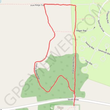
Name: Birds Hill Park - Prairie Winds Trail trail, distance, elevation, map, profile, GPS track
End: Prairie Winds Trail, Rural Municipality of Springfield, Manitoba, Canada (49.99850 -96.88800)
Coordinates: 49.99773 -96.89188 50.00406 -96.88786
Topography: Rural Municipality of Springfield topographic map, elevation, terrain
Thank you for supporting this site ❤️
Make a donation
Make a donation
Gear up for your next adventure:
As an Amazon Associate, this site earns from qualifying purchases at no extra cost to you.