Thank you for supporting this site ❤️
Make a donation
Make a donation
Gear up for your next adventure:
As an Amazon Associate, this site earns from qualifying purchases at no extra cost to you.
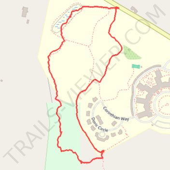
Walking the northeast part of Overlook's trails
Though toward the end the way we took really wasn't a trail anymore.
- Distance: 1.9 Km
- Elevation gain: 41 m
- Maximum elevation: 272 m
- Elevation loss: 40 m
- Minimum elevation: 245 m
- Moving time: 46 m 12 s
- Moving speed: 2.5 Km/h
- Maximum speed: 5.7 Km/h
- Total time: 1 h 10 s
- Global speed: 1.9 Km/h
Interactive trail map
Thank you for supporting this site ❤️
Make a donation
Make a donation
Gear up for your next adventure:
As an Amazon Associate, this site earns from qualifying purchases at no extra cost to you.
Trail profile
- Distance: 1.9 Km
- Elevation gain: 41 m
- Maximum elevation: 272 m
- Elevation loss: 40 m
- Minimum elevation: 245 m
- Moving time: 46 m 12 s
- Moving speed: 2.5 Km/h
- Maximum speed: 5.7 Km/h
- Total time: 1 h 10 s
- Global speed: 1.9 Km/h
Thank you for supporting this site ❤️
Make a donation
Make a donation
Gear up for your next adventure:
As an Amazon Associate, this site earns from qualifying purchases at no extra cost to you.
About this trail
Name: Walking the northeast part of Overlook's trails trail, distance, elevation, map, profile, GPS track
Coordinates: 42.13681 -71.98396 42.14238 -71.98044
Thank you for supporting this site ❤️
Make a donation
Make a donation
Gear up for your next adventure:
As an Amazon Associate, this site earns from qualifying purchases at no extra cost to you.