Timna Park Sightseeing
סובב תמנע קטן: ביקור באטרקציות פארק תמנע
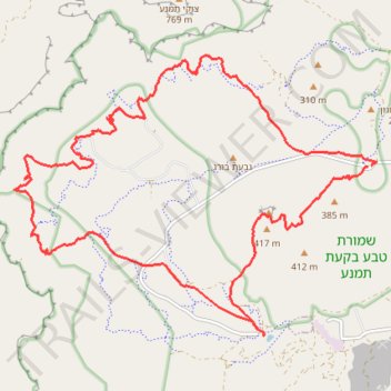
- Distance: 25.4 Km
- Elevation gain: 668 m
- Maximum elevation: 439 m
- Elevation loss: 666 m
- Minimum elevation: 184 m
Interactive trail map
Trail profile
- Distance: 25.4 Km
- Elevation gain: 668 m
- Maximum elevation: 439 m
- Elevation loss: 666 m
- Minimum elevation: 184 m
About this trail
Name: Timna Park Sightseeing trail, distance, elevation, map, profile, GPS track
Start: Hevel Eilot Regional Council, Beersheba Subdistrict, South District, Israel (29.78760 34.98954)
Coordinates: 29.75987 34.92250 29.80574 34.99051
Other hiking, mountain biking, running and outdoor activity trails
Click on a trail to view its statistics, map and profile.
Marathon Timna Circle
Israel > South District > Hevel Eilot Regional Council > Yotvata
מרתון סובב תמנע: סובב מוניומנטי של בקעת תמנע מיוטבתה לבאר אורה
Distance: 42.4 Km • Elevation gain: 1,359 m • Maximum elevation: 837 m
Timna Park Circle
Israel > South District > Hevel Eilot Regional Council
סובב תמנע גדול: מעלה מלחן, הר ברך והר תמנע
Distance: 29.4 Km • Elevation gain: 1,172 m • Maximum elevation: 837 m