Thank you for supporting this site ❤️
Make a donation
Make a donation
Gear up for your next adventure:
As an Amazon Associate, this site earns from qualifying purchases at no extra cost to you.
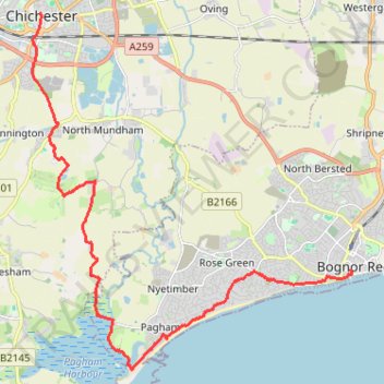
Walk from Chichester to Bognor
- Distance: 18.5 Km
- Elevation gain: 44 m
- Maximum elevation: 20 m
- Elevation loss: 58 m
- Minimum elevation: -2 m
- Moving time: 4 h 26 m
- Moving speed: 4.2 Km/h
- Maximum speed: 7.7 Km/h
- Total time: 6 h 55 m
- Global speed: 2.7 Km/h
Interactive trail map
Thank you for supporting this site ❤️
Make a donation
Make a donation
Gear up for your next adventure:
As an Amazon Associate, this site earns from qualifying purchases at no extra cost to you.
Trail profile
- Distance: 18.5 Km
- Elevation gain: 44 m
- Maximum elevation: 20 m
- Elevation loss: 58 m
- Minimum elevation: -2 m
- Moving time: 4 h 26 m
- Moving speed: 4.2 Km/h
- Maximum speed: 7.7 Km/h
- Total time: 6 h 55 m
- Global speed: 2.7 Km/h
Thank you for supporting this site ❤️
Make a donation
Make a donation
Gear up for your next adventure:
As an Amazon Associate, this site earns from qualifying purchases at no extra cost to you.
About this trail
Name: Walk from Chichester to Bognor trail, distance, elevation, map, profile, GPS track
Coordinates: 50.76145 -0.78230 50.83659 -0.67538
Thank you for supporting this site ❤️
Make a donation
Make a donation
Gear up for your next adventure:
As an Amazon Associate, this site earns from qualifying purchases at no extra cost to you.