
Noccalula Falls and Gorge Loop Trail via Black Creek Trail in Noccalula Falls Park
The Noccalula Falls and Gorge Loop Trail offers a scenic mix of forested paths, rocky terrain, and breathtaking views of Noccalula Falls cascading into the gorge below. Hikers are drawn to the unique perspective offered by trails that pass beneath the falls and by a suspension bridge spanning the creek, giving a closer look at the rugged landscape. With its moderate difficulty and well-maintained pathways, the trail is an inviting option for nature enthusiasts seeking both adventure and serenity in Gadsden's beautiful parklands. #Hiking #Loop #Gorge #Waterfall #River #Forest #Nature
- Distance: 3.2 Km
- Elevation gain: 71 m
- Maximum elevation: 216 m
- Elevation loss: 71 m
- Minimum elevation: 170 m
Interactive trail map
Trail profile
- Distance: 3.2 Km
- Elevation gain: 71 m
- Maximum elevation: 216 m
- Elevation loss: 71 m
- Minimum elevation: 170 m
About this trail
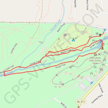
Name: Noccalula Falls and Gorge Loop Trail via Black Creek Trail in Noccalula Falls Park trail, distance, elevation, map, profile, GPS track
Start: Mann Drive, Gadsden, Etowah County, Alabama, 35904, United States (34.04203 -86.02116)
End: Mann Drive, Gadsden, Etowah County, Alabama, 35904, United States (34.04202 -86.02116)
Coordinates: 34.03858 -86.03062 34.04203 -86.02116