Make a donation
Gear up for your next adventure:
As an Amazon Associate, this site earns from qualifying purchases at no extra cost to you.
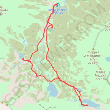
Bynderishki Lakes (circular)
- Distance: 7.9 Km
- Elevation gain: 469 m
- Maximum elevation: 2,332 m
- Elevation loss: 471 m
- Minimum elevation: 1,972 m
- Moving time: 3 h 33 m
- Moving speed: 2.2 Km/h
- Maximum speed: 8.6 Km/h
- Total time: 7 h 47 s
- Global speed: 1.1 Km/h
Interactive trail map
Make a donation
Gear up for your next adventure:
As an Amazon Associate, this site earns from qualifying purchases at no extra cost to you.
Trail profile
- Distance: 7.9 Km
- Elevation gain: 469 m
- Maximum elevation: 2,332 m
- Elevation loss: 471 m
- Minimum elevation: 1,972 m
- Moving time: 3 h 33 m
- Moving speed: 2.2 Km/h
- Maximum speed: 8.6 Km/h
- Total time: 7 h 47 s
- Global speed: 1.1 Km/h
Make a donation
Gear up for your next adventure:
As an Amazon Associate, this site earns from qualifying purchases at no extra cost to you.
About this trail
Name: Bynderishki Lakes (circular) trail, distance, elevation, map, profile, GPS track
Start: без пътека, Bansko, Blagoevgrad, Bulgaria (41.75676 23.41630)
End: Bansko, Blagoevgrad, Bulgaria (41.75668 23.41645)
Coordinates: 41.73486 23.40636 41.75676 23.42525
Make a donation
Gear up for your next adventure:
As an Amazon Associate, this site earns from qualifying purchases at no extra cost to you.
Other hiking, mountain biking, running and outdoor activity trails
Click on a trail to view its statistics, map and profile.
Vihren Hut - Demyanitsa Hut
Distance: 15.5 Km • Elevation gain: 661 m • Maximum elevation: 2,588 m
Pirin 17/08/2023 Vihren Hut - Kazana - Vihren summit - Vihre...
Distance: 8.2 Km • Elevation gain: 960 m • Maximum elevation: 2,908 m
Vihren hut - Vihren - Koncheto - Banski Sukodol - Kazana - V...
Distance: 11.8 Km • Elevation gain: 1,309 m • Maximum elevation: 2,906 m