Thank you for supporting this site ❤️
Make a donation
Make a donation
Gear up for your next adventure:
As an Amazon Associate, this site earns from qualifying purchases at no extra cost to you.
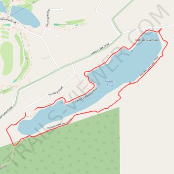
Hidden Lake Loop Trail
Description:
- Distance: 3.0 Km
- Elevation gain: 54 m
- Maximum elevation: 209 m
- Elevation loss: 53 m
- Minimum elevation: 181 m
- Moving time: 38 m 58 s
- Moving speed: 4.6 Km/h
- Maximum speed: 10.0 Km/h
- Total time: 41 m 8 s
- Global speed: 4.3 Km/h
Interactive trail map
Thank you for supporting this site ❤️
Make a donation
Make a donation
Gear up for your next adventure:
As an Amazon Associate, this site earns from qualifying purchases at no extra cost to you.
Trail profile
- Distance: 3.0 Km
- Elevation gain: 54 m
- Maximum elevation: 209 m
- Elevation loss: 53 m
- Minimum elevation: 181 m
- Moving time: 38 m 58 s
- Moving speed: 4.6 Km/h
- Maximum speed: 10.0 Km/h
- Total time: 41 m 8 s
- Global speed: 4.3 Km/h
Thank you for supporting this site ❤️
Make a donation
Make a donation
Gear up for your next adventure:
As an Amazon Associate, this site earns from qualifying purchases at no extra cost to you.
About this trail
Name: Hidden Lake Loop Trail trail, distance, elevation, map, profile, GPS track
Coordinates: 41.04876 -75.05548 41.05556 -75.04302
Thank you for supporting this site ❤️
Make a donation
Make a donation
Gear up for your next adventure:
As an Amazon Associate, this site earns from qualifying purchases at no extra cost to you.