Droughty Ridgeline Trail North (Rokeby Hills)
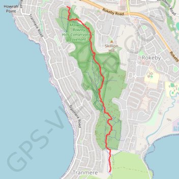
This trail runs the ridgeline of the Rokeby Hills Bushland Reserve. Starting at the end of Mayfair Crt enter the reserve and head straight up to the top of Kuynah reserve. From here there are blue markers(arrows) to keep users on the primary ridgeline track which is also the fire trail along the reserve. The trail is relatively low gradient apart from one section that descends and ascends into and out of a larger saddle 2/3 into the trail. This trail would suit half day walks, mountain bike riding or even horse riding. There are plenty of other side tracks that can be explored and by returning to the top of the hill you can easily navigate your way back to the main trail. There are an abundance of native wildlife including a huge variety of Birdlife to spot along the trail. The trail is managed by the Rokeby Hills Community Landcare Group Inc
- Distance: 3.9 Km
- Elevation gain: 121 m
- Maximum elevation: 155 m
- Elevation loss: 133 m
- Minimum elevation: 65 m
- Moving time: 58 m 51 s
- Moving speed: 4.0 Km/h
- Maximum speed: 7.3 Km/h
- Total time: 1 h 11 s
- Global speed: 3.9 Km/h
Interactive trail map
Trail profile
- Distance: 3.9 Km
- Elevation gain: 121 m
- Maximum elevation: 155 m
- Elevation loss: 133 m
- Minimum elevation: 65 m
- Moving time: 58 m 51 s
- Moving speed: 4.0 Km/h
- Maximum speed: 7.3 Km/h
- Total time: 1 h 11 s
- Global speed: 3.9 Km/h
About this trail
Name: Droughty Ridgeline Trail North (Rokeby Hills) trail, distance, elevation, map, profile, GPS track
Coordinates: -42.91395 147.41552 -42.88786 147.42519
Other hiking, mountain biking, running and outdoor activity trails
Click on a trail to view its statistics, map and profile.