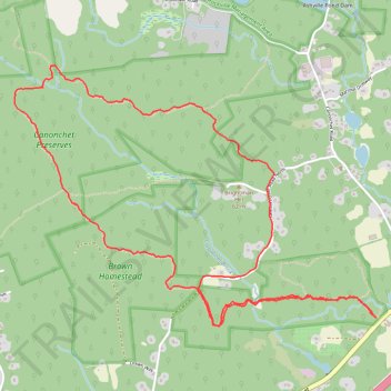
Canonchet Preserves hiking loop trails
- Distance: 8.6 Km
- Elevation gain: 125 m
- Maximum elevation: 103 m
- Elevation loss: 125 m
- Minimum elevation: 31 m
- Moving time: 2 h 13 m
- Moving speed: 3.9 Km/h
- Maximum speed: 7.4 Km/h
- Total time: 2 h 51 m
- Global speed: 3.0 Km/h
Interactive trail map
Trail profile
- Distance: 8.6 Km
- Elevation gain: 125 m
- Maximum elevation: 103 m
- Elevation loss: 125 m
- Minimum elevation: 31 m
- Moving time: 2 h 13 m
- Moving speed: 3.9 Km/h
- Maximum speed: 7.4 Km/h
- Total time: 2 h 51 m
- Global speed: 3.0 Km/h
About this trail
Name: Canonchet Preserves hiking loop trails trail, distance, elevation, map, profile, GPS track
Start: Yellow, Hopkinton, South County, Rhode Island, 02832, United States (41.48216 -71.74751)
End: Yellow, Hopkinton, South County, Rhode Island, 02832, United States (41.48216 -71.74757)
Coordinates: 41.48168 -71.77463 41.49635 -71.74751