Thank you for supporting this site ❤️
Make a donation
Make a donation
Gear up for your next adventure:
As an Amazon Associate, this site earns from qualifying purchases at no extra cost to you.
Walloon - Woolshed
Interactive trail map
Thank you for supporting this site ❤️
Make a donation
Make a donation
Gear up for your next adventure:
As an Amazon Associate, this site earns from qualifying purchases at no extra cost to you.
Trail profile
- Distance: 59.9 Km
- Elevation gain: 898 m
- Maximum elevation: 245 m
- Elevation loss: 898 m
- Minimum elevation: 37 m
Thank you for supporting this site ❤️
Make a donation
Make a donation
Gear up for your next adventure:
As an Amazon Associate, this site earns from qualifying purchases at no extra cost to you.
About this trail
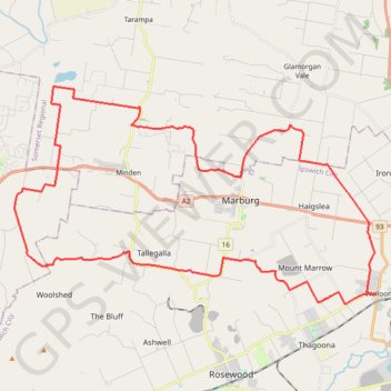
Name: Walloon - Woolshed trail, distance, elevation, map, profile, GPS track
Coordinates: -27.60987 152.48728 -27.51575 152.66358
Thank you for supporting this site ❤️
Make a donation
Make a donation
Gear up for your next adventure:
As an Amazon Associate, this site earns from qualifying purchases at no extra cost to you.
Other hiking, mountain biking, running and outdoor activity trails
Click on a trail to view its statistics, map and profile.
Brisbane Valley Rail Trail: Fernvale - Borallon
Australia > Queensland > Fernvale
Distance: 11.0 Km • Elevation gain: 75 m • Maximum elevation: 76 m