Thank you for supporting this site ❤️
Make a donation
Make a donation
Gear up for your next adventure:
As an Amazon Associate, this site earns from qualifying purchases at no extra cost to you.
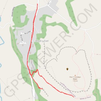
Craig Nant Dulas
Conwy Walking
- Distance: 2.7 Km
- Elevation gain: 114 m
- Maximum elevation: 151 m
- Elevation loss: 114 m
- Minimum elevation: 69 m
- Moving time: 46 m 45 s
- Moving speed: 3.4 Km/h
- Maximum speed: 5.7 Km/h
- Total time: 2 h 9 m
- Global speed: 1.2 Km/h
Interactive trail map
Thank you for supporting this site ❤️
Make a donation
Make a donation
Gear up for your next adventure:
As an Amazon Associate, this site earns from qualifying purchases at no extra cost to you.
Trail profile
- Distance: 2.7 Km
- Elevation gain: 114 m
- Maximum elevation: 151 m
- Elevation loss: 114 m
- Minimum elevation: 69 m
- Moving time: 46 m 45 s
- Moving speed: 3.4 Km/h
- Maximum speed: 5.7 Km/h
- Total time: 2 h 9 m
- Global speed: 1.2 Km/h
Thank you for supporting this site ❤️
Make a donation
Make a donation
Gear up for your next adventure:
As an Amazon Associate, this site earns from qualifying purchases at no extra cost to you.
About this trail
Name: Craig Nant Dulas trail, distance, elevation, map, profile, GPS track
Coordinates: 53.27097 -3.63351 53.27831 -3.62740
Thank you for supporting this site ❤️
Make a donation
Make a donation
Gear up for your next adventure:
As an Amazon Associate, this site earns from qualifying purchases at no extra cost to you.