Mailbox Peak Old Trail
Hike to Mailbox Peak in Middle Fork Snoqualmie Natural Resources Conservation Area #Hiking #Mountain #Forest
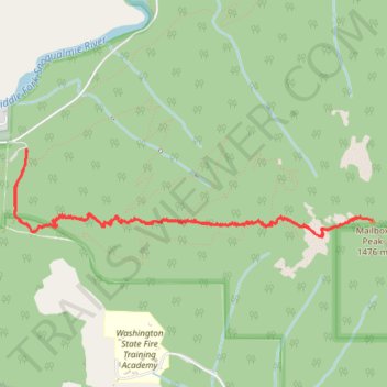
- Distance: 8.8 Km
- Elevation gain: 1,186 m
- Maximum elevation: 1,442 m
- Elevation loss: 1,188 m
- Minimum elevation: 253 m
- Moving time: 2 h 38 m
- Moving speed: 3.3 Km/h
- Maximum speed: 14.5 Km/h
- Total time: 3 h 50 m
- Global speed: 2.3 Km/h
Interactive trail map
Trail profile
- Distance: 8.8 Km
- Elevation gain: 1,186 m
- Maximum elevation: 1,442 m
- Elevation loss: 1,188 m
- Minimum elevation: 253 m
- Moving time: 2 h 38 m
- Moving speed: 3.3 Km/h
- Maximum speed: 14.5 Km/h
- Total time: 3 h 50 m
- Global speed: 2.3 Km/h
About this trail
Name: Mailbox Peak Old Trail trail, distance, elevation, map, profile, GPS track
Start: Grouse Ridge way, King County, Washington, United States (47.46690 -121.67238)
End: Grouse Ridge way, King County, Washington, United States (47.46699 -121.67250)
Coordinates: 47.46128 -121.67366 47.46699 -121.63930
Other hiking, mountain biking, running and outdoor activity trails
Click on a trail to view its statistics, map and profile.
Mailbox Peak Old Trail in Middle Fork Snoqualmie Natural Resources Conservation Area
United States > Washington > King County
The Mailbox Peak Old Trail offers a strenuous ascent through dense forests, with the path often steep and rugged, leading to a summit crowned with the iconic mailbox. Along the way, hikers are treated to panoramic vistas of the Snoqualmie Valley, the Cascade Range, the distant Seattle skyline, and, on clear…
Distance: 8.2 Km • Elevation gain: 1,176 m • Maximum elevation: 1,441 m
Mailbox Peak Trail in Middle Fork Snoqualmie Natural Resources Conservation Area
United States > Washington > King County
The Mailbox Peak Trail in Washington State offers hikers a challenging ascent through dense forests, with the reward of panoramic views at the summit. Along the way, the trail features creek crossings and, upon reaching higher elevations, opens up to vistas of Mount Rainier and the surrounding Cascade Range.…
Distance: 16.5 Km • Elevation gain: 1,272 m • Maximum elevation: 1,442 m
Northern part of the Pacific Crest Trail (PCT)
United States > Oregon > Klamath County
Hike on the Pacific Crest National Scenic Trail from Crater Lake to Canada Border through Oregon and Washington along the Sierra Nevada and Cascade mountain ranges. #Hiking #Mountain #SierraNevada #Cascade #Nature #Forest #Park #PCT
Distance: 1,198.3 Km • Elevation gain: 44,308 m • Maximum elevation: 2,307 m