Thank you for supporting this site ❤️
Make a donation
Make a donation
Gear up for your next adventure:
As an Amazon Associate, this site earns from qualifying purchases at no extra cost to you.
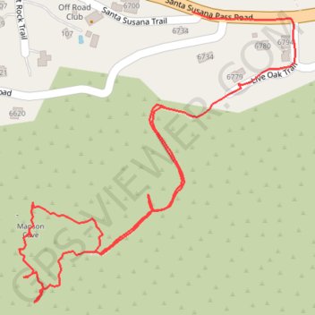
The real Manson Cave
- Distance: 1.6 Km
- Elevation gain: 84 m
- Maximum elevation: 456 m
- Elevation loss: 118 m
- Minimum elevation: 350 m
- Moving time: 32 m 5 s
- Moving speed: 3.0 Km/h
- Maximum speed: 6.0 Km/h
- Total time: 1 h 45 m
- Global speed: 0.9 Km/h
Interactive trail map
Thank you for supporting this site ❤️
Make a donation
Make a donation
Gear up for your next adventure:
As an Amazon Associate, this site earns from qualifying purchases at no extra cost to you.
Trail profile
- Distance: 1.6 Km
- Elevation gain: 84 m
- Maximum elevation: 456 m
- Elevation loss: 118 m
- Minimum elevation: 350 m
- Moving time: 32 m 5 s
- Moving speed: 3.0 Km/h
- Maximum speed: 6.0 Km/h
- Total time: 1 h 45 m
- Global speed: 0.9 Km/h
Thank you for supporting this site ❤️
Make a donation
Make a donation
Gear up for your next adventure:
As an Amazon Associate, this site earns from qualifying purchases at no extra cost to you.
About this trail
Name: The real Manson Cave trail, distance, elevation, map, profile, GPS track
Coordinates: 34.25623 -118.66056 34.25981 -118.65645
Thank you for supporting this site ❤️
Make a donation
Make a donation
Gear up for your next adventure:
As an Amazon Associate, this site earns from qualifying purchases at no extra cost to you.