Make a donation
Gear up for your next adventure:
As an Amazon Associate, this site earns from qualifying purchases at no extra cost to you.
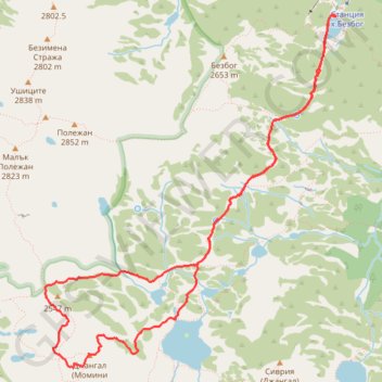
Bezbog hut - Dzhangal (2730) - Popovo ezero - Bezbog hut
- Distance: 11.2 Km
- Elevation gain: 839 m
- Maximum elevation: 2,700 m
- Elevation loss: 839 m
- Minimum elevation: 2,195 m
- Moving time: 4 h 6 m
- Moving speed: 2.7 Km/h
- Maximum speed: 6.2 Km/h
- Total time: 5 h 34 m
- Global speed: 2.0 Km/h
Interactive trail map
Make a donation
Gear up for your next adventure:
As an Amazon Associate, this site earns from qualifying purchases at no extra cost to you.
Trail profile
- Distance: 11.2 Km
- Elevation gain: 839 m
- Maximum elevation: 2,700 m
- Elevation loss: 839 m
- Minimum elevation: 2,195 m
- Moving time: 4 h 6 m
- Moving speed: 2.7 Km/h
- Maximum speed: 6.2 Km/h
- Total time: 5 h 34 m
- Global speed: 2.0 Km/h
Make a donation
Gear up for your next adventure:
As an Amazon Associate, this site earns from qualifying purchases at no extra cost to you.
About this trail
Name: Bezbog hut - Dzhangal (2730) - Popovo ezero - Bezbog hut trail, distance, elevation, map, profile, GPS track
Start: Бай Славе, Bansko, Blagoevgrad, Bulgaria (41.73374 23.52428)
End: Бай Славе, Bansko, Blagoevgrad, Bulgaria (41.73382 23.52423)
Coordinates: 41.70561 23.49303 41.73392 23.52428
Make a donation
Gear up for your next adventure:
As an Amazon Associate, this site earns from qualifying purchases at no extra cost to you.
Other hiking, mountain biking, running and outdoor activity trails
Click on a trail to view its statistics, map and profile.
Bezbog Hut - Popovo Lake - Bezbog Hut
Distance: 7.6 Km • Elevation gain: 411 m • Maximum elevation: 2,365 m
Bezbog Hut - Mt. Polezhan - Mt. Bezbog - Bezbog Hut
Distance: 8.1 Km • Elevation gain: 689 m • Maximum elevation: 2,831 m