Munro Hillwalk Aonach Mor
Munro, hillwalk, Aonach, Mor
- Distance: 17.4 Km
- Elevation gain: 1,277 m
- Maximum elevation: 1,219 m
- Elevation loss: 1,282 m
- Minimum elevation: 101 m
- Moving time: 5 h 57 m
- Moving speed: 2.9 Km/h
- Maximum speed: 8.4 Km/h
- Total time: 6 h 27 m
- Global speed: 2.7 Km/h
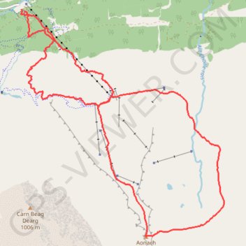
Interactive trail map
Trail profile
- Distance: 17.4 Km
- Elevation gain: 1,277 m
- Maximum elevation: 1,219 m
- Elevation loss: 1,282 m
- Minimum elevation: 101 m
- Moving time: 5 h 57 m
- Moving speed: 2.9 Km/h
- Maximum speed: 8.4 Km/h
- Total time: 6 h 27 m
- Global speed: 2.7 Km/h
About this trail
Name: Munro Hillwalk Aonach Mor trail, distance, elevation, map, profile, GPS track
Start: The Wiggle, Highland, Scotland, PH33 6SQ, United Kingdom (56.85083 -4.99910)
Coordinates: 56.81294 -5.00005 56.85121 -4.93751
Other hiking, mountain biking, running and outdoor activity trails
Click on a trail to view its statistics, map and profile.
Great Glen Way (Fort William to Fort Augustus)
United Kingdom > Scotland > Highland > Fort William
Distance: 52.6 Km • Elevation gain: 598 m • Maximum elevation: 108 m