Thank you for supporting this site ❤️
Make a donation
Make a donation
Gear up for your next adventure:
As an Amazon Associate, this site earns from qualifying purchases at no extra cost to you.
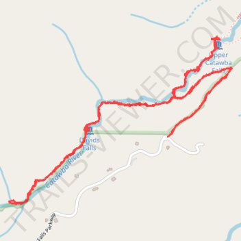
Catawba falls hiking
- Distance: 6.3 Km
- Elevation gain: 177 m
- Maximum elevation: 809 m
- Elevation loss: 178 m
- Minimum elevation: 715 m
- Moving time: 1 h 29 m
- Moving speed: 4.2 Km/h
- Maximum speed: 10.7 Km/h
- Total time: 2 h 10 m
- Global speed: 2.9 Km/h
Interactive trail map
Thank you for supporting this site ❤️
Make a donation
Make a donation
Gear up for your next adventure:
As an Amazon Associate, this site earns from qualifying purchases at no extra cost to you.
Trail profile
- Distance: 6.3 Km
- Elevation gain: 177 m
- Maximum elevation: 809 m
- Elevation loss: 178 m
- Minimum elevation: 715 m
- Moving time: 1 h 29 m
- Moving speed: 4.2 Km/h
- Maximum speed: 10.7 Km/h
- Total time: 2 h 10 m
- Global speed: 2.9 Km/h
Thank you for supporting this site ❤️
Make a donation
Make a donation
Gear up for your next adventure:
As an Amazon Associate, this site earns from qualifying purchases at no extra cost to you.
About this trail
Name: Catawba falls hiking trail, distance, elevation, map, profile, GPS track
Coordinates: 35.59348 -82.26122 35.60238 -82.24660
Thank you for supporting this site ❤️
Make a donation
Make a donation
Gear up for your next adventure:
As an Amazon Associate, this site earns from qualifying purchases at no extra cost to you.