Make a donation
Gear up for your next adventure:
As an Amazon Associate, this site earns from qualifying purchases at no extra cost to you.
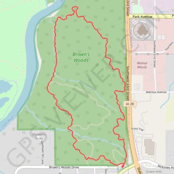
Brown's Woods Loop Trail in Iowa
This Brown's Woods loop trail in West Des Moines offers a delightful hiking experience through a scenic woodland setting. As you traverse the trail, you’ll encounter a rich variety of wildlife, including deer and numerous bird species, amidst a backdrop of towering trees and lush undergrowth, making it a perfect spot for nature lovers and birdwatchers. The peaceful ambiance, combined with well-maintained paths, ensures that hikers can enjoy both the tranquility and natural beauty of this preserve year-round. #Hiking #Loop #Forest #Nature
- Distance: 5.2 Km
- Elevation gain: 79 m
- Maximum elevation: 287 m
- Elevation loss: 78 m
- Minimum elevation: 241 m
- Moving time: 41 m 28 s
- Moving speed: 7.6 Km/h
- Maximum speed: 11.3 Km/h
- Total time: 43 m
- Global speed: 7.3 Km/h
Interactive trail map
Make a donation
Gear up for your next adventure:
As an Amazon Associate, this site earns from qualifying purchases at no extra cost to you.
Trail profile
- Distance: 5.2 Km
- Elevation gain: 79 m
- Maximum elevation: 287 m
- Elevation loss: 78 m
- Minimum elevation: 241 m
- Moving time: 41 m 28 s
- Moving speed: 7.6 Km/h
- Maximum speed: 11.3 Km/h
- Total time: 43 m
- Global speed: 7.3 Km/h
Make a donation
Gear up for your next adventure:
As an Amazon Associate, this site earns from qualifying purchases at no extra cost to you.
About this trail
Name: Brown's Woods Loop Trail in Iowa trail, distance, elevation, map, profile, GPS track
Start: Brown's Woods Drive, West Des Moines, Polk County, Iowa, 50265, United States (41.54107 -93.70400)
End: Brown's Woods Drive, West Des Moines, Polk County, Iowa, 50321, United States (41.54120 -93.70390)
Coordinates: 41.54103 -93.71368 41.55648 -93.70356
Make a donation
Gear up for your next adventure:
As an Amazon Associate, this site earns from qualifying purchases at no extra cost to you.