
Garden of the Gods Observation Loop Trail in Garden of the Gods Wilderness
The Garden of the Gods Observation Loop Trail offers a remarkable hiking experience, showcasing stunning views and unique rock formations. As you traverse the trail, you'll encounter notable landmarks like Camel Rock and Devil's Smokestack, alongside breathtaking overlooks that reveal the lush Shawnee National Forest landscape. The tranquility of the setting, especially during autumn when foliage bursts into vibrant colors, makes this trail a true gem for nature lovers and photographers alike. #Hiking #Loop #Rock #Forest #Nature
- Distance: 0.8 Km
- Elevation gain: 19 m
- Maximum elevation: 244 m
- Elevation loss: 19 m
- Minimum elevation: 228 m
- Moving time: 20 m 15 s
- Moving speed: 2.4 Km/h
- Maximum speed: 5.2 Km/h
- Total time: 25 m 30 s
- Global speed: 1.9 Km/h
Interactive trail map
Trail profile
- Distance: 0.8 Km
- Elevation gain: 19 m
- Maximum elevation: 244 m
- Elevation loss: 19 m
- Minimum elevation: 228 m
- Moving time: 20 m 15 s
- Moving speed: 2.4 Km/h
- Maximum speed: 5.2 Km/h
- Total time: 25 m 30 s
- Global speed: 1.9 Km/h
About this trail
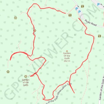
Name: Garden of the Gods Observation Loop Trail in Garden of the Gods Wilderness trail, distance, elevation, map, profile, GPS track
Start: Picnic Road, Saline County, Illinois, 62947, United States (37.60472 -88.38465)
Coordinates: 37.60310 -88.38635 37.60500 -88.38427