Thank you for supporting this site ❤️
Make a donation
Make a donation
Gear up for your next adventure:
As an Amazon Associate, this site earns from qualifying purchases at no extra cost to you.
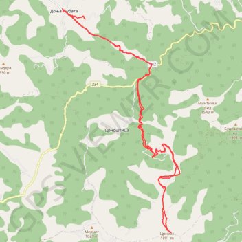
Trenutna trasa: 21 TRA 2019 08:33
- Distance: 31.8 Km
- Elevation gain: 1,465 m
- Maximum elevation: 1,876 m
- Elevation loss: 1,361 m
- Minimum elevation: 897 m
Interactive trail map
Thank you for supporting this site ❤️
Make a donation
Make a donation
Gear up for your next adventure:
As an Amazon Associate, this site earns from qualifying purchases at no extra cost to you.
Trail profile
- Distance: 31.8 Km
- Elevation gain: 1,465 m
- Maximum elevation: 1,876 m
- Elevation loss: 1,361 m
- Minimum elevation: 897 m
Thank you for supporting this site ❤️
Make a donation
Make a donation
Gear up for your next adventure:
As an Amazon Associate, this site earns from qualifying purchases at no extra cost to you.
About this trail
Name: Trenutna trasa: 21 TRA 2019 08:33 trail, distance, elevation, map, profile, GPS track
Coordinates: 42.42393 22.34311 42.49904 22.39659
Thank you for supporting this site ❤️
Make a donation
Make a donation
Gear up for your next adventure:
As an Amazon Associate, this site earns from qualifying purchases at no extra cost to you.