GoMap__2024_09_03__18_55_47
- Distance: 8.0 Km
- Elevation gain: 14 m
- Maximum elevation: 1,397 m
- Elevation loss: 77 m
- Minimum elevation: 1,330 m
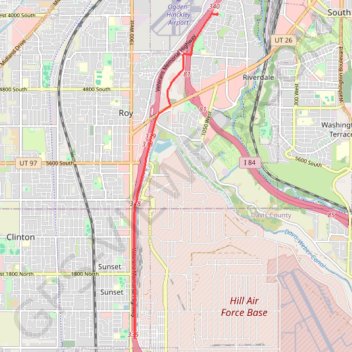
Interactive trail map
Trail profile
- Distance: 8.0 Km
- Elevation gain: 14 m
- Maximum elevation: 1,397 m
- Elevation loss: 77 m
- Minimum elevation: 1,330 m
About this trail
Name: GoMap__2024_09_03__18_55_47 trail, distance, elevation, map, profile, GPS track
Start: Veterans Memorial Highway, Sunset, Davis County, Utah, 84015, United States (41.12705 -112.02505)
End: Parker Drive, Riverdale, Weber County, Utah, 84401, United States (41.19095 -112.00330)
Coordinates: 41.12705 -112.02515 41.19104 -112.00326