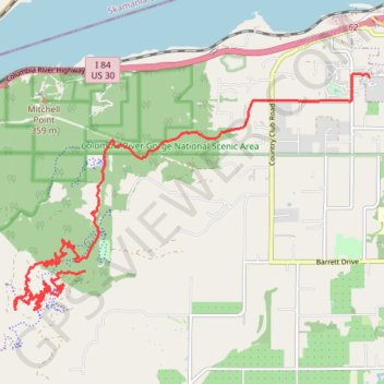
Post Canyon from Family Man to Hood River
Mountain Bike in Post Canyon from Family Man Staging Area to Hood River via Seven Streams and Flume Creek. Columbia River Gorge National Scenic Area. #MTB #Canyon #Mountain #Forest #River #Nature
- Distance: 15.6 Km
- Elevation gain: 476 m
- Maximum elevation: 630 m
- Elevation loss: 738 m
- Minimum elevation: 148 m
Interactive trail map
Trail profile
- Distance: 15.6 Km
- Elevation gain: 476 m
- Maximum elevation: 630 m
- Elevation loss: 738 m
- Minimum elevation: 148 m
About this trail
Name: Post Canyon from Family Man to Hood River trail, distance, elevation, map, profile, GPS track
Start: Riordan Hill Drive, Hood River County, Oregon, United States (45.67715 -121.60640)
Coordinates: 45.67185 -121.62015 45.70391 -121.55117
Other hiking, mountain biking, running and outdoor activity trails
Click on a trail to view its statistics, map and profile.
Northern part of the Pacific Crest Trail (PCT)
United States > Oregon > Klamath County
Hike on the Pacific Crest National Scenic Trail from Crater Lake to Canada Border through Oregon and Washington along the Sierra Nevada and Cascade mountain ranges. #Hiking #Mountain #SierraNevada #Cascade #Nature #Forest #Park #PCT
Distance: 1,198.3 Km • Elevation gain: 44,308 m • Maximum elevation: 2,307 m
Post Canyon
United States > Oregon > Hood River County
#MTB
Distance: 22.4 Km • Elevation gain: 786 m • Maximum elevation: 745 m
MTB ride in Hood River
United States > Oregon > Hood River County
Distance: 17.9 Km • Elevation gain: 636 m • Maximum elevation: 620 m