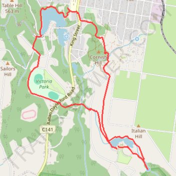
Two Lakes Loop - Daylesford
- Distance: 8.6 Km
- Elevation gain: 197 m
- Maximum elevation: 600 m
- Elevation loss: 199 m
- Minimum elevation: 531 m
- Moving time: 2 h 1 m
- Moving speed: 4.2 Km/h
- Maximum speed: 6.0 Km/h
- Total time: 2 h 39 m
- Global speed: 3.2 Km/h
Interactive trail map
Trail profile
- Distance: 8.6 Km
- Elevation gain: 197 m
- Maximum elevation: 600 m
- Elevation loss: 199 m
- Minimum elevation: 531 m
- Moving time: 2 h 1 m
- Moving speed: 4.2 Km/h
- Maximum speed: 6.0 Km/h
- Total time: 2 h 39 m
- Global speed: 3.2 Km/h
About this trail
Name: Two Lakes Loop - Daylesford trail, distance, elevation, map, profile, GPS track
Start: Lerderderg Track, Daylesford, Shire of Hepburn, Victoria, 3460, Australia (-37.36603 144.14892)
End: Lerderderg Track, Daylesford, Shire of Hepburn, Victoria, 3460, Australia (-37.36559 144.14926)
Coordinates: -37.36893 144.13306 -37.34583 144.15445
Other hiking, mountain biking, running and outdoor activity trails
Click on a trail to view its statistics, map and profile.