Thank you for supporting this site ❤️
Make a donation
Make a donation
Gear up for your next adventure:
As an Amazon Associate, this site earns from qualifying purchases at no extra cost to you.
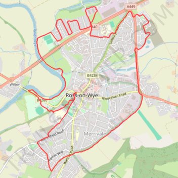
Ross-on-Wye loop
- Distance: 12.7 Km
- Elevation gain: 134 m
- Maximum elevation: 71 m
- Elevation loss: 133 m
- Minimum elevation: 30 m
- Moving time: 1 h 13 m
- Moving speed: 10.3 Km/h
- Maximum speed: 15.4 Km/h
- Total time: 1 h 13 m
- Global speed: 10.3 Km/h
Interactive trail map
Thank you for supporting this site ❤️
Make a donation
Make a donation
Gear up for your next adventure:
As an Amazon Associate, this site earns from qualifying purchases at no extra cost to you.
Trail profile
- Distance: 12.7 Km
- Elevation gain: 134 m
- Maximum elevation: 71 m
- Elevation loss: 133 m
- Minimum elevation: 30 m
- Moving time: 1 h 13 m
- Moving speed: 10.3 Km/h
- Maximum speed: 15.4 Km/h
- Total time: 1 h 13 m
- Global speed: 10.3 Km/h
Thank you for supporting this site ❤️
Make a donation
Make a donation
Gear up for your next adventure:
As an Amazon Associate, this site earns from qualifying purchases at no extra cost to you.
About this trail
Name: Ross-on-Wye loop trail, distance, elevation, map, profile, GPS track
Coordinates: 51.90277 -2.59672 51.92720 -2.56739
Thank you for supporting this site ❤️
Make a donation
Make a donation
Gear up for your next adventure:
As an Amazon Associate, this site earns from qualifying purchases at no extra cost to you.
Other hiking, mountain biking, running and outdoor activity trails
Click on a trail to view its statistics, map and profile.
Dean2023-311
United Kingdom > England > Oxfordshire > Oxford
Distance: 310.3 Km • Elevation gain: 3,366 m • Maximum elevation: 290 m