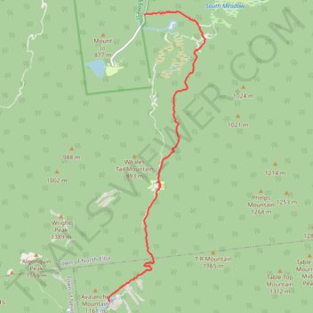
Avalanche Lake Ski
- Distance: 10.1 Km
- Elevation gain: 135 m
- Maximum elevation: 939 m
- Elevation loss: 414 m
- Minimum elevation: 619 m
- Moving time: 2 h 4 m
- Moving speed: 4.9 Km/h
- Maximum speed: 36.3 Km/h
- Total time: 2 h 23 m
- Global speed: 4.2 Km/h
Interactive trail map
Trail profile
- Distance: 10.1 Km
- Elevation gain: 135 m
- Maximum elevation: 939 m
- Elevation loss: 414 m
- Minimum elevation: 619 m
- Moving time: 2 h 4 m
- Moving speed: 4.9 Km/h
- Maximum speed: 36.3 Km/h
- Total time: 2 h 23 m
- Global speed: 4.2 Km/h
About this trail
Name: Avalanche Lake Ski trail, distance, elevation, map, profile, GPS track
Start: Avalanche Pass Trail, Town of Keene, Essex County, New York, United States (44.13382 -73.96541)
End: South Meadows Road, Town of North Elba, Essex County, New York, United States (44.19352 -73.95534)
Coordinates: 44.13382 -73.96583 44.19412 -73.93777
Other hiking, mountain biking, running and outdoor activity trails
Click on a trail to view its statistics, map and profile.
Mount Redfield and Cliff Mountain
United States > New York > Essex County
Hike from Heart Lake to Mount Redfield and Cliff Mountain via Van Hoevenberg Trail, Marcy Dam, Avalanche Pass Trail, Avalanche Camp, Lake Arnold Trail, Lake Arnold, Mount Marcy Trail, Mount Redfield Trail and Cliff Mountain Trail in the High Peaks Wilderness and Adirondack Park. #Hiking #Mountain #Nature…
Distance: 29.7 Km • Elevation gain: 1,399 m • Maximum elevation: 1,388 m
Mount Marcy, Mount Skylight and Gray Peak
United States > New York > Essex County > Town of Keene
Return hike from Mount Marcy to Heart Lake via Mount Marcy Trail, Schofield Cobble, Four Corners, Skylight Trail, Lake Tear of the Clouds, Gray Peak Trail, Van Hoevenberg Trail, Indian Falls and Marcy Dam Pond in the High Peaks Wilderness and the Adirondack Park. #Hiking #Mountain #Nature #Forest #Lake #Falls…
Distance: 17.9 Km • Elevation gain: 607 m • Maximum elevation: 1,612 m
Mount Marcy via Van Hoevenberg Trail in High Peaks Wilderness
United States > New York > Essex County
The Van Hoevenberg Trail to Mount Marcy is one of the most popular routes to summit New York's highest peak. The route offers a mix of forested sections, notable landmarks like the Marcy Dam and Indian Falls with its scenic views of the MacIntyre Range, and a thrilling rock-scramble to the summit as the…
Distance: 24.1 Km • Elevation gain: 1,029 m • Maximum elevation: 1,612 m
Mount Marcy, Table Top and Phelps Mountain
United States > New York > Essex County
Hike from Heart Lake to Mount Marcy, Table Top and Phelps Mountain via Van Hoevenberg Trail, Marcy Dam, Phelps Mountain Trail, Indian Falls and Tabletop Mountain Trail in the High Peaks Wilderness and the Adirondacks Park. #Hiking #Mountain #Nature #Forest #Lake #Falls #River #Wilderness #Park
Distance: 29.5 Km • Elevation gain: 1,679 m • Maximum elevation: 1,612 m
Mount Colden Loop
United States > New York > Essex County
Loop hike from Heart Lake to Mount Colden via Van Hoevenberg Trail, Marcy Dam Pond, Avalanche Pass Trail, Avalanche Pass, Avalanche Lake, Lake Colden, Mount Colden Trail, L. Morgan Porter Trail, Lake Arnold and Lake Arnold Trail in the High Peaks Wilderness and the Adirondack Park. #Hiking #Loop #Mountain…
Distance: 21.7 Km • Elevation gain: 1,000 m • Maximum elevation: 1,415 m
Mount Skylight
United States > New York > Essex County
Hike to Mount Skylight via Adirondack Loj Road, Heart Lake, Van Hoevenberg Trail, Marcy Dam, Avalanche Pass Trail, Avalanche Camp, Lake Arnold Trail, Lake Arnold, Mount Marcy Trail, Lake Tear of the Clouds, Four Corners and Skylight Trail in the High Peaks Wilderness and the Adirondack Park. #Hiking #Mountain…
Distance: 33.0 Km • Elevation gain: 1,295 m • Maximum elevation: 1,492 m