Thank you for supporting this site ❤️
Make a donation
Make a donation
Gear up for your next adventure:
As an Amazon Associate, this site earns from qualifying purchases at no extra cost to you.
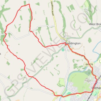
Sandy Ford
- Distance: 14.0 Km
- Elevation gain: 206 m
- Maximum elevation: 208 m
- Elevation loss: 206 m
- Minimum elevation: 53 m
Interactive trail map
Thank you for supporting this site ❤️
Make a donation
Make a donation
Gear up for your next adventure:
As an Amazon Associate, this site earns from qualifying purchases at no extra cost to you.
Trail profile
- Distance: 14.0 Km
- Elevation gain: 206 m
- Maximum elevation: 208 m
- Elevation loss: 206 m
- Minimum elevation: 53 m
Thank you for supporting this site ❤️
Make a donation
Make a donation
Gear up for your next adventure:
As an Amazon Associate, this site earns from qualifying purchases at no extra cost to you.
About this trail
Name: Sandy Ford trail, distance, elevation, map, profile, GPS track
Coordinates: 53.86812 -2.45702 53.90517 -2.39366
Thank you for supporting this site ❤️
Make a donation
Make a donation
Gear up for your next adventure:
As an Amazon Associate, this site earns from qualifying purchases at no extra cost to you.