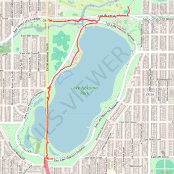
New Nokomis paths
- Distance: 4.4 Km
- Elevation gain: 17 m
- Maximum elevation: 260 m
- Elevation loss: 18 m
- Minimum elevation: 249 m
- Moving time: 16 m 44 s
- Moving speed: 15.6 Km/h
- Maximum speed: 28.7 Km/h
- Total time: 33 m 28 s
- Global speed: 7.8 Km/h
Interactive trail map
Trail profile
- Distance: 4.4 Km
- Elevation gain: 17 m
- Maximum elevation: 260 m
- Elevation loss: 18 m
- Minimum elevation: 249 m
- Moving time: 16 m 44 s
- Moving speed: 15.6 Km/h
- Maximum speed: 28.7 Km/h
- Total time: 33 m 28 s
- Global speed: 7.8 Km/h
About this trail
Name: New Nokomis paths trail, distance, elevation, map, profile, GPS track
Coordinates: 44.90062 -93.24767 44.91731 -93.23525