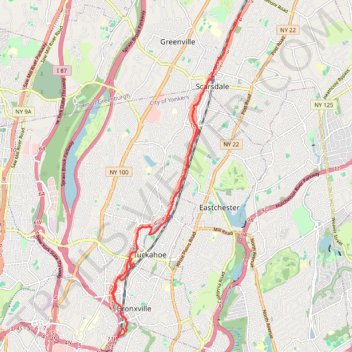
Bronx River Pathway
- Distance: 22.2 Km
- Elevation gain: 154 m
- Maximum elevation: 56 m
- Elevation loss: 154 m
- Minimum elevation: 26 m
Interactive trail map
Trail profile
- Distance: 22.2 Km
- Elevation gain: 154 m
- Maximum elevation: 56 m
- Elevation loss: 154 m
- Minimum elevation: 26 m
About this trail
Name: Bronx River Pathway trail, distance, elevation, map, profile, GPS track
Coordinates: 40.93114 -73.83890 41.00494 -73.79997
Other hiking, mountain biking, running and outdoor activity trails
Click on a trail to view its statistics, map and profile.
Eastchester, walk around lake in Twin Lakes Park
United States > New York > Westchester County > Town of Eastchester
Distance: 7.3 Km • Elevation gain: 47 m • Maximum elevation: 53 m
Hunt's Woods Park
United States > New York > Westchester County > City of Mount Vernon > Village of Bronxville
Distance: 3.3 Km • Elevation gain: 19 m • Maximum elevation: 44 m
Twin Lakes Park trails
United States > New York > Westchester County > Town of Eastchester
Distance: 10.0 Km • Elevation gain: 79 m • Maximum elevation: 54 m
Greenburgh Nature Center Trails
United States > New York > Westchester County > Greenville
Distance: 6.5 Km • Elevation gain: 67 m • Maximum elevation: 111 m