Thank you for supporting this site ❤️
Make a donation
Make a donation
Gear up for your next adventure:
As an Amazon Associate, this site earns from qualifying purchases at no extra cost to you.
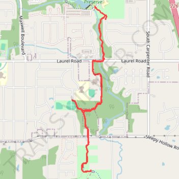
Plum Creek Greenway
- Distance: 6.8 Km
- Elevation gain: 56 m
- Maximum elevation: 343 m
- Elevation loss: 52 m
- Minimum elevation: 328 m
- Moving time: 19 m 51 s
- Moving speed: 20.5 Km/h
- Maximum speed: 31.4 Km/h
- Total time: 19 m 51 s
- Global speed: 20.5 Km/h
Interactive trail map
Thank you for supporting this site ❤️
Make a donation
Make a donation
Gear up for your next adventure:
As an Amazon Associate, this site earns from qualifying purchases at no extra cost to you.
Trail profile
- Distance: 6.8 Km
- Elevation gain: 56 m
- Maximum elevation: 343 m
- Elevation loss: 52 m
- Minimum elevation: 328 m
- Moving time: 19 m 51 s
- Moving speed: 20.5 Km/h
- Maximum speed: 31.4 Km/h
- Total time: 19 m 51 s
- Global speed: 20.5 Km/h
Thank you for supporting this site ❤️
Make a donation
Make a donation
Gear up for your next adventure:
As an Amazon Associate, this site earns from qualifying purchases at no extra cost to you.
About this trail
Name: Plum Creek Greenway trail, distance, elevation, map, profile, GPS track
Coordinates: 41.21229 -81.81428 41.23389 -81.80830
Thank you for supporting this site ❤️
Make a donation
Make a donation
Gear up for your next adventure:
As an Amazon Associate, this site earns from qualifying purchases at no extra cost to you.
Other hiking, mountain biking, running and outdoor activity trails
Click on a trail to view its statistics, map and profile.
Plum Creek Park
United States > Ohio > Medina County
Distance: 5.0 Km • Elevation gain: 65 m • Maximum elevation: 354 m