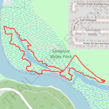
Bonanza Loop Trail - Seminole Valley Park
- Distance: 4.3 Km
- Elevation gain: 31 m
- Maximum elevation: 231 m
- Elevation loss: 30 m
- Minimum elevation: 219 m
- Moving time: 1 h 10 m
- Moving speed: 3.6 Km/h
- Maximum speed: 4.3 Km/h
- Total time: 1 h 10 m
- Global speed: 3.6 Km/h
Interactive trail map
Trail profile
- Distance: 4.3 Km
- Elevation gain: 31 m
- Maximum elevation: 231 m
- Elevation loss: 30 m
- Minimum elevation: 219 m
- Moving time: 1 h 10 m
- Moving speed: 3.6 Km/h
- Maximum speed: 4.3 Km/h
- Total time: 1 h 10 m
- Global speed: 3.6 Km/h
About this trail
Name: Bonanza Loop Trail - Seminole Valley Park trail, distance, elevation, map, profile, GPS track
Start: Shelter Trail, Cedar Rapids, Linn County, Iowa, 52405, United States (42.00220 -91.73005)
End: Shelter Trail, Cedar Rapids, Linn County, Iowa, 52405, United States (42.00233 -91.73028)
Coordinates: 42.00214 -91.74456 42.00822 -91.72999