Make a donation
Gear up for your next adventure:
As an Amazon Associate, this site earns from qualifying purchases at no extra cost to you.
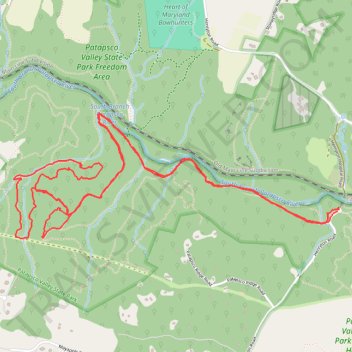
Patapsco State Park - Sykesville Henryton Area
- Distance: 10.2 Km
- Elevation gain: 147 m
- Maximum elevation: 149 m
- Elevation loss: 147 m
- Minimum elevation: 96 m
- Moving time: 1 h 24 m
- Moving speed: 7.3 Km/h
- Maximum speed: 12.7 Km/h
- Total time: 1 h 26 m
- Global speed: 7.1 Km/h
Interactive trail map
Make a donation
Gear up for your next adventure:
As an Amazon Associate, this site earns from qualifying purchases at no extra cost to you.
Trail profile
- Distance: 10.2 Km
- Elevation gain: 147 m
- Maximum elevation: 149 m
- Elevation loss: 147 m
- Minimum elevation: 96 m
- Moving time: 1 h 24 m
- Moving speed: 7.3 Km/h
- Maximum speed: 12.7 Km/h
- Total time: 1 h 26 m
- Global speed: 7.1 Km/h
Make a donation
Gear up for your next adventure:
As an Amazon Associate, this site earns from qualifying purchases at no extra cost to you.
About this trail
Name: Patapsco State Park - Sykesville Henryton Area trail, distance, elevation, map, profile, GPS track
Start: HoCo Thru Trail, Marriottsville, Howard County, Maryland, 21104, United States (39.35040 -76.91402)
End: Henryton Road, Marriottsville, Howard County, Maryland, 21104, United States (39.35033 -76.91411)
Coordinates: 39.34864 -76.93961 39.35626 -76.91400
Make a donation
Gear up for your next adventure:
As an Amazon Associate, this site earns from qualifying purchases at no extra cost to you.
Other hiking, mountain biking, running and outdoor activity trails
Click on a trail to view its statistics, map and profile.
Patapsco State Park - Sykesville/Henryton area
United States > Maryland > Howard County > Marriottsville
Distance: 9.3 Km • Elevation gain: 227 m • Maximum elevation: 169 m