Thank you for supporting this site ❤️
Make a donation
Make a donation
Gear up for your next adventure:
As an Amazon Associate, this site earns from qualifying purchases at no extra cost to you.
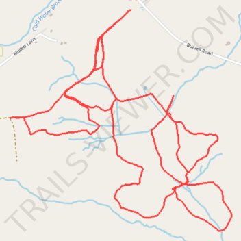
Harris Farms Cross Country Ski
- Distance: 8.9 Km
- Elevation gain: 104 m
- Maximum elevation: 67 m
- Elevation loss: 104 m
- Minimum elevation: 39 m
- Moving time: 1 h 24 m
- Moving speed: 6.3 Km/h
- Maximum speed: 24.3 Km/h
- Total time: 1 h 35 m
- Global speed: 5.6 Km/h
Interactive trail map
Thank you for supporting this site ❤️
Make a donation
Make a donation
Gear up for your next adventure:
As an Amazon Associate, this site earns from qualifying purchases at no extra cost to you.
Trail profile
- Distance: 8.9 Km
- Elevation gain: 104 m
- Maximum elevation: 67 m
- Elevation loss: 104 m
- Minimum elevation: 39 m
- Moving time: 1 h 24 m
- Moving speed: 6.3 Km/h
- Maximum speed: 24.3 Km/h
- Total time: 1 h 35 m
- Global speed: 5.6 Km/h
Thank you for supporting this site ❤️
Make a donation
Make a donation
Gear up for your next adventure:
As an Amazon Associate, this site earns from qualifying purchases at no extra cost to you.
About this trail
Name: Harris Farms Cross Country Ski trail, distance, elevation, map, profile, GPS track
Start: Buzzell Road, Dayton, York County, Maine, 04005, United States (43.52797 -70.57516)
End: Buzzell Road, Dayton, York County, Maine, 04005, United States (43.52809 -70.57491)
Coordinates: 43.51613 -70.58401 43.52809 -70.56743
Thank you for supporting this site ❤️
Make a donation
Make a donation
Gear up for your next adventure:
As an Amazon Associate, this site earns from qualifying purchases at no extra cost to you.